Published March 4, 2026 10:29AM
The One Big Beautiful Bill Act and the Battle for the Maah Daah Hey Trail
A beloved 144-mile singletrack route in North Dakota is ground zero for the Trump administration's erasure of recreation from public lands management.
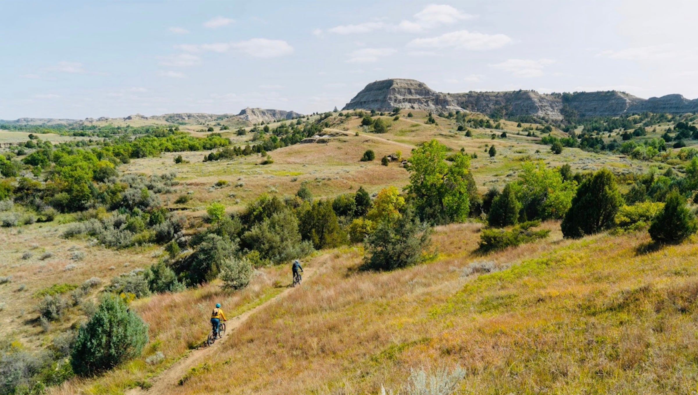
Cyclists on North Dakota's Maah Daah Hey Trail (Photo: Courtesy of Western Spirit)
This story is from RE:PUBLIC, a nonprofit newsroom covering public lands issues. Sign up for RE:PUBLIC’s newsletter here.
Late last year, three recreation groups with an interest in protecting the Maah Daah Hey Trail—a popular 144-mile singletrack route for hikers, mountain bikers, and horseback riders that winds through the Badlands of western North Dakota—noticed something strange. The Bureau of Land Management (BLM) had started the process of selling lease rights to 23 oil and gas parcels in the vicinity of the trail, nine of which are right on top of it or very close. If the sales go through and drilling eventually commences, large portions of the trail could, in theory, become unusable, forcing a reroute to keep it viable as a recreation setting.
Since its creation in the late 1990s, the trail has earned a reputation as a premier outdoor destination. The Boulder, Colorado-based International Mountain Bicycling Association maintains a list of what it calls IMBA Epics—trails in North America and other parts of the world that it considers first-class routes. The Maah Daah Hey is the only trail listed in the Dakotas, joining singletrack gems like Utah’s Hurricane Rim Loop and the Aspen Snowmass Mega Loop. Last summer, Outside called it one of the seven best bikepacking routes in the U.S.
The threat to the Maah Daah Hey is more than a local land dispute. It’s the clearest example yet of a fundamental reversal in how the federal government values public land—one in which recreation interests, more recently afforded equal footing alongside ranchers, loggers, and energy companies, have effectively been erased by the Trump administration’s aggressive push for oil and gas development. And with last summer’s Big Beautiful Bill Act stripping the BLM of its discretion to protect any area from leasing, few recreation destinations on federal land is safe from the same fate.
ADVERTISEMENT
In a letter to the BLM sent in early January, the three groups—the Outdoor Alliance (based in Washington, D.C.), IMBA, and Public Lands Solutions (Moab, Utah)—objected to the sale. Citing “substantial risk of surface occupancy, road construction, flaring, lighting, noise, dust, and visual intrusion that would materially impair the trail’s recreational and scenic values,” the petitioners asked the BLM to hit pause unless it can “demonstrate enforceable leasing-stage protections adequate to avoid impairment.”
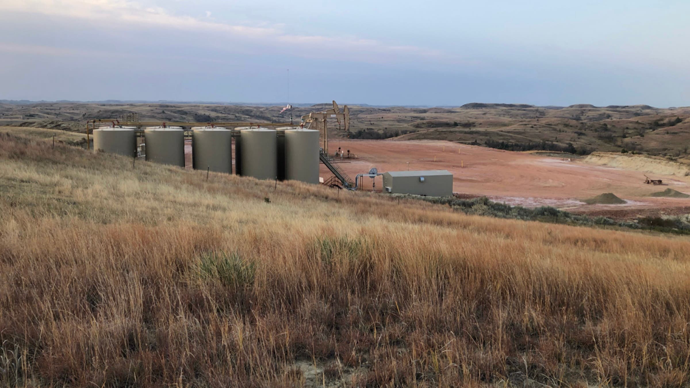
“Surface occupancy” means well pads. Not all pads are alike, but a footprint on the larger side involves five to ten acres of cleared, packed ground that serves as the hub for drilling equipment, which can include wellheads, pump jacks, tanks, wastewater storage pits, trailers, and flare stacks. According to a 2020 Department of Agriculture document that discusses oil and gas development of the grasslands where the trail is located, drill pads are expected to involve four to seven acres of initial disturbance, which would be reduced to an acre or less as the site is maintained. Drill rigs would typically rise to 100 feet or more.
“If surface occupancy is allowed, drillers would build roads wherever they think is most convenient,” says Ashley Korenblat, managing director of Public Lands Solutions and the CEO of a Moab-based guiding company called Western Spirit Cycling Adventures, which runs trips on the Maah Daah Hey. “The trail goes right through the proposed parcels, so it would be degraded or, possibly, completely destroyed. Maybe you could jump on an oil and gas road to get to another part of it, maybe not. But do you really want to camp next to a pump jack at a site that, for sure, will be leaking methane and other unhealthy gases? At some point, the recreation experience is gone.”
ADVERTISEMENT
That’s a drastic outcome, but it’s not inevitable. For one thing, companies that buy lease rights don’t always use them, a decision that’s influenced over time by the price of oil and gas.
In addition, one of the available “leasing-stage protections” would be the use of modern directional drilling technology that could position well pads a mile or two away from the trail. In advance of a sale, however, BLM rules don’t require oil and gas companies to commit to a strategy like that, which can cost much more than straight-down drilling.
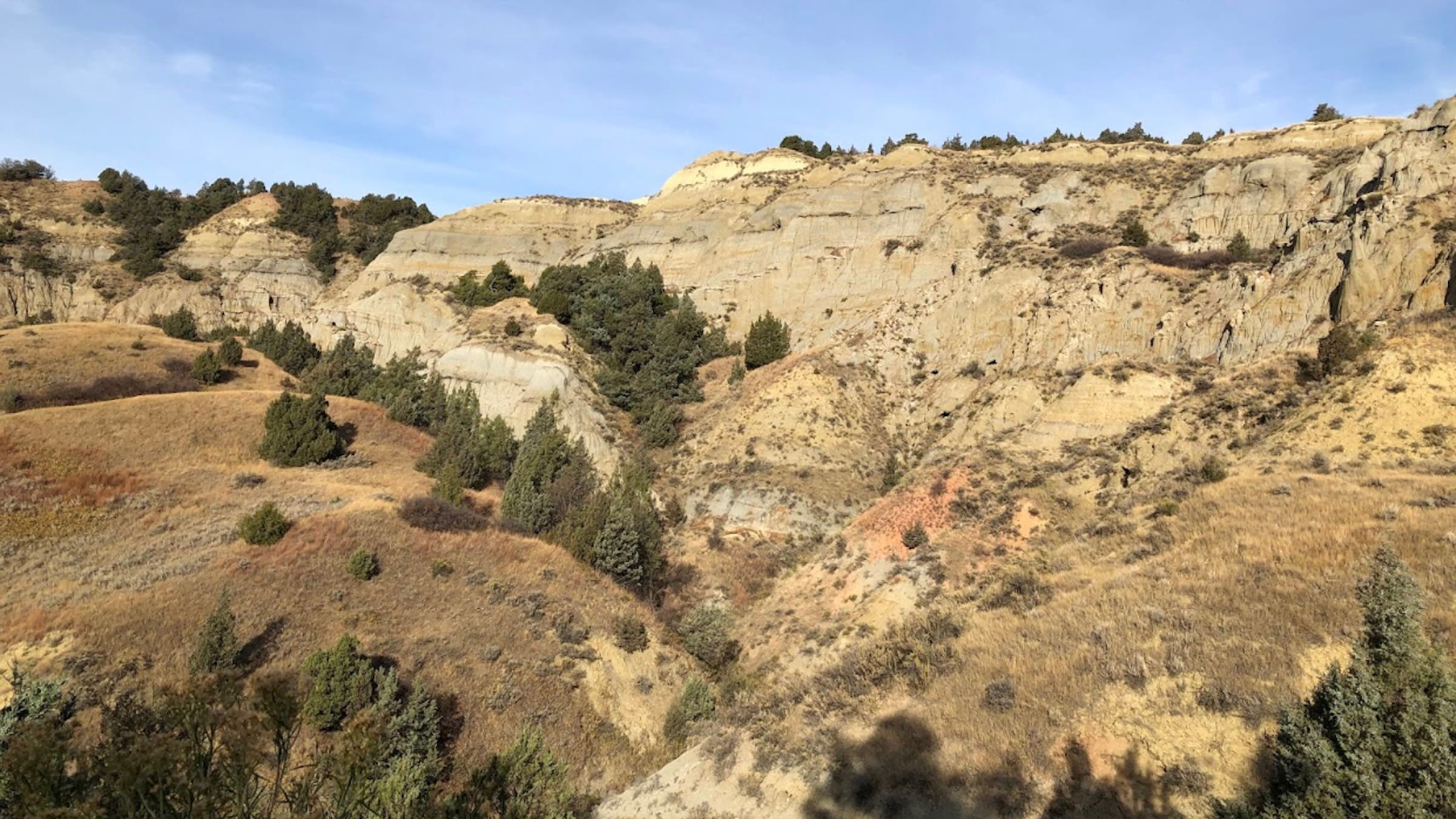
The trail sits atop North Dakota’s famous Bakkan oil field, a 200,000-square-mile resource that covers parts of North Dakota, Montana, Saskatchewan, and Manitoba. Not surprisingly, drilling has been common in this region, and current trail users occasionally come into view of infrastructure from past projects, including rusty tanks and pump jacks.
ADVERTISEMENT
“The trail is 144 miles long, and there are probably six places where you can see signs of drilling operations,” says Shannon Straight, executive director of the Badlands Conservation Alliance, a Bismarck-based nonprofit that works to protect wild landscapes in North Dakota. Straight backpacked the entire trail in 2020, documenting industrial leftovers along the way. “When I see the photos I took of those places now,” he says, “my sadness is that there probably will be more.”
As this situation plays out, it’s important to bear in mind a background reality: The lease sale’s parameters are in lockstep with President Donald Trump’s aggressive energy goals, which are laid out in his signature piece of legislation: H.R.-1, also known as the One Big Beautiful Bill Act.
Among other things, H.R. 1 voided the BLM’s gatekeeping power in a sale like this. One Capitol Hill staffer who keeps track of the agency puts it this way: “Under H.R. 1, it actually doesn’t matter anymore if there are conflicts or other uses in an area where oil and gas companies want to drill. The bill takes away BLM’s discretion to decide where or whether to lease.”
ADVERTISEMENT
The groups that protested to the BLM aren’t alone in monitoring what this might mean on the ground. In late January, a group that includes the Coalition to Protect America’s National Parks and The Wilderness Society called attention to pending lease sales of 39 parcels that could affect, among other sites, Utah’s Dinosaur National Monument. Three of the proposed parcels, their letter pointed out, are approximately 10 miles from a visitor center at monument’s southern entrance. New Mexico has seen a similar, long-running dispute about allowing drilling operations that close to Chaco Culture National Historical Park.
For its part, the BLM isn’t commenting. In response to questions about the leasing plan—and objections from recreational users—a spokesperson said only that the agency is accepting public input on the proposed leases during a 30-day period that started on February 19. If the sale goes forward, it’s scheduled for April 28.
Dedicated in 1999 after a multi-year planning process, the Maah Daah Hey Trail was a joint effort that involved cooperation among Theodore Roosevelt National Park, the U.S. Forest Service Dakota Prairie Grasslands, and North Dakota State Parks and Recreation. It connects three different areas of the park: the sprawling north and south units and Elkhorn Ranch, Roosevelt’s home base during his transformative years in North Dakota in the 1880s. In a lease offering for the third quarter of 2026, six parcels are listed that are within five miles or less of the Theodore Roosevelt Wilderness Area, which is part of the national park’s north unit.
ADVERTISEMENT
Named for a Mandan word meaning “long-lasting area”—and known for rugged, demanding terrain that includes canyons, buttes, rolling prairie, and river crossings—the trail has been an economic boon to North Dakota. According to the North Dakota Outdoor Industry Association, public assets like the park and the trail are part of a statewide recreation economy that generates $3.1 billion annually and produces more jobs than mining, quarrying, and oil and gas extraction.
Such benefits were part of the original vision. In the summer of 1999, when the trail debuted, Scott Fitzwilliams—a ranger with the Little Missouri National Grasslands who was central to its creation—said the trail reflected a major shift in management thinking in the U.S. Forest Service. “Nationwide, we are going through the biggest metamorphosis in the agency probably since Gifford Pinchot,” he told a local newspaper. The trail, he said, was emblematic of a change in which recreation interests were afforded the same importance as the interests of ranchers and oil executives.
Right now, however, there’s no sign the Trump administration cares at all about recreational uses. In a marked departure from the administration of President Joe Biden, H.R.-1 doesn’t just allow, but requires, the BLM to conduct lease sales, mandating a minimum of four every year in nine oil-producing Western states: North Dakota, Montana, Wyoming, Colorado, Utah, Oklahoma, New Mexico, Nevada, and Alaska.
ADVERTISEMENT
The law also repeals a provision of Biden’s Inflation Reduction Act that required oil companies to pay $5 an acre when they ask the government to consider offering new parcels for leasing. And it requires the BLM to offer up no fewer than 50 percent of nominated parcels as part of each quarterly lease sale, and to initiate the process of making a decision on all such nominations within 18 months.
Finally, H.R.-1 bypasses a Biden measure called the Onshore Oil and Gas Leasing Rule, under which the BLM was told to concentrate lease sales in areas that have proven drilling potential and existing infrastructure. The goal was to cut back on new sales that could lead to harming what the Biden-era BLM called “critical wildlife habitat, cultural resources, and recreational values …”
Such considerations were erased by H.R.-1.
“The people who wrote the law wanted to severely restrict the BLM’s ability to defer nominated parcels from lease sales,” says Justin Meuse, government relations director for The Wilderness Society. “In the past, that has happened due to factors like potential conflicts with recreation and the need for habitat protection.”
ADVERTISEMENT
As Korenblat explains, there are several more stages in the process, including approval of the site’s Resource Management Plan (RMP), as required by the National Environmental Policy Act (NEPA). “The land use plan is the first place where some limits can be placed on oil and gas leasing,” she says. These limits are called stipulations. One example of a stipulation would be requiring that the oil can only be accessed through directional drilling.
But it’s unknown what will happen during this and other steps. Over the past year, the Trump administration has used the Congressional Review Act—a 1996 law that allows presidents to overturn rules implemented at the end of a previous administration—to overturn several land use plans, including one written for a different area in North Dakota. Using the act, congressional Republicans undid an RMP for the entire state, which was passed during the Biden Administration. The Maah Daah Hey Trail is now covered under a 1988 RMP that was written before it even existed.
“The ramifications of all this are extremely unclear,” Korenblat says. “Without an up-to-date resource management plan, all permits for any activity on public land are untethered to their authorizing legislation, the Federal Land Policy and Management Act. Absolute worst case: This kind of work is intended to undermine the entire federal land system.”